Wednesday 22 July 2015

Swimming at Shepperton

Rowan and I had a lovely swim at the Shepperton Lakes.

The lakes are on the West side of London next to the River Thames.
It is a beautiful location, within an large and private park. The lake is exclusively for swimmers and ducks.

This is a fantastic facility for open water swimming and a good opportunity to test out my new tri-suit. I enjoyed it so much that I returned on Saturday morning for another swim.

They have moored buoys to mark out two routes. One is 400m and the other 750m.

 I remained very warm in the wetsuit and it was very comfortable for swimming.

I will be back.

Friday 3 July 2015

The Glamorgan Ridgeway

The Glamorgan Ridgeway is a scenic long distance path from North of Newport to Llanharan.

I had two Duke of Edinburgh Award groups to monitor and the weather forecast was poor. As it turned out the weather was much better than expected, no thunderstorms and just a little light rain.

Day 2 of their expedition took them from Llantrisant over Mynydd Garthmaelwg on forest tracks.


I decided to track them on my mountain bike so that I could move around faster on the forest trails.


The Ridgeway leaves the forest and flows over farmland at Mynydd Meiros. I stayed in the forest and headed to the NW tip where a track exits that I could use on my bike.


The track gently undulates heading towards Mynydd Portref with the wind turbines standing tall against the blue sky. 

I carried on over mynydd Hugh and was picked up where the minor road crosses from Brynna. 

Wednesday 1 July 2015

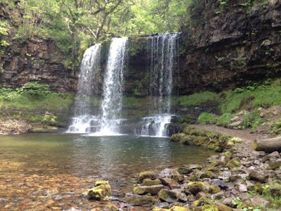
Sgwd yr Eira


We have had a few days of unusually hot weather for the UK,  the July record was broken at Heathrow  Airport with a temperature of 36.7C.

With that in mind I decided to take the school group to Sgwd yr Eira rather than Pen y Fan; especially as thundery showers were forecast. The inquest into the death of three SAS soldiers in July last year has been in the news over the last few weeks and the press would have a feast if a school group got into difficulties. Anyway the Hepste gorge would be in the shade. 
The river Hepste plunges over a 30m cliff at Sgwd yr Eira (Fall of Snow). The underlying rock is limestone but a resistant band of millstone grit provides the ledge for the falls. 
A footpath follows a natural rock shelf behind the falls allowing walkers to cross the river behind the falls.

This is a classic walk, one not to be missed. 

Monday 29 June 2015

Black Mountain traverse

This weekend was spent supervising Duke of Edinburgh groups on their Gold and Silver practice expeditions.
We spent the Friday night camping at the Red Kite Feeding Station near Llandeusant.
Pwll y Cig in the Black Mountain
The route headed south on the lanes through Llandeusant an into the access land at Twyn Draintewion and Pen Rhiw Goch near Careg Ogof. I followed the groups at a distance keeping an eye on their progress and ensuring that they remained on route, but sufficiently behind so that they were unaware of my presence. The route becomes rather vague as the Afon Twrch is approached but is clearer from then onwards. The path improves towards Afon Geidd and becomes a track from here onwards to Glyntawe. The swallow holes are impressive some are full of water which Toffee took advantage of for a quick swim.
We spent the night at the campsite next to Dan yr Orgof caves where all the midges of Wales live!

Day 2 the cloud was down and it was raining, The groups of explorer scouts walked across the beautiful limestone moors of the Ogof Ffynnon Ddu National Nature Reserve to Porth yr Ogorf near Ysradfellte on the Beacons Way. What a pity they could not enjoy it fully. The area has a lot of history being used for quarrying, and rabbit farming.
The sun came out just as they finished.

Saturday 20 June 2015

Kempton Park Pumping Station


Kempton Park Pumping Station is one of the steam powered pumping stations that kept London supplied with water.

 It is a massive construction and if you like steam power this is going to impress due to its sheer size.

Consists of two triple expansion steam engines one at each end of the grand Art Deco building.

Each engine is 19 meters (62ft 6in) high, weighing 1016 tonnes.

 The engines ran from 1927 to 1980 pumping 19 million gallons of water a day.


One engine has been restored to running order while the other triple has been partly dismantled enabling visitors to see the inner workings of the engine.


Pin valves supplying oil to various parts of the engine

One of the big ends!


Connecting rod and small end at the top.
If you like steam power this will appeal. I could not get enough of the sound, small and sight of this massive engine.

Thanks to Rowan for the photographs.

Saturday 13 June 2015

Budleigh Salterton

Budleigh Salterton is located on the south Devon coast between Exmouth and Sidmouth. It's name derives from salt panning that took place here up to the 18 Century. Salt was sold by the monks to surrounding villages as a preservative for storing meat.
We parked at the eastern end of the town in the car park on the estuary of the River Otter. There are remains of Lime Kilns here for the production of lime used in rendering houses and adding to farmland.
Our walk for the day was to take us along the coast towards Sidmouth but head inland to Otterton then back down the River Otter to Budleigh Salterton.
From the car park we headed north following the River Otter towards Ottery as far as the first bridge. There are good views of the estuary with various birds such as Egrets.
We crossed the bridge and headed on the footpath on the other side of the estuary back towards the sea at Otterton Ledge with views back towards the estuary mouth and Budleigh Salterton.


We continued east on the coast path that heads towards Sidmouth along the cliff tops. The cliffs re a beautiful red Jurassic limestone and in places they are crumbling so it is wise to keep away from the edge.


The fields were fringed with bright red poppies and the cliff tops covered in Sea Pinks and red campion. Sea campion and thistle were also in flower.


The coast path passes places with interesting names that indicate what happened here in the past.
Brandy Head had obvious connections with smuggling but more recently was used in testing various guns for aircraft used in WWII. A derelict observation hut and information display is all that is now left.
Ladram bay with Sidmouth in the distance


We continued on the gently undulating path to Smallstones Point to see Ladram Bay that has some impressive sea stacks off the beach. Unfortunately the little valley has been totally spoilt by a massive static caravan park.


From Smallstones point we headed inland on a footpath to join a track and a minor road that leads to Ottery.


The pretty village had a stream running down the main street, lots of cute houses and a grand church set high above the village.
 We stopped for tea and cakes in the Mill before crossing the river Otter and following the footpath along the west bank all the way to the our start in the Lime Kiln car park.

Monday 25 May 2015

The Tarren Hills

Where I hear you say?
These hills are overshadowed by Cadair Idris on the other side of the Talylyn Valley. 
I think they are well worth a visit as they should provide fine views over the Dovey Estuary and Cadair Idris. I sound unsure because we were mostly in low cloud. The only views we had were limited to parts of the Dovey Estuary. 
We parked in Abergwynolwyn and headed up the beautiful valley of Nant Gwernol, with cascades and emerald green pools. 

Of course, Toffee couldn't resist a swim. 
The first mountain top of the day was Tarrenhendre (634m), an uninspiring top made more so by the veil of cloud obscuring our views. 
The second top Tarren y Gesail (667m) was again shrouded in mist, so no views, but significantly this was my last 2000ft mountain top in Wales! 190 visited in the 7 years since my 50th birthday. 


Now I need to finish the English tops. 52 left to do out of the 252 in England. 

Sunday 24 May 2015

A fine mountain top in the Arans

What a beautiful and unassuming mountain top!
What made it so good was a grand cairn on the top of a rocky outcrop, fantastic views of so many other mountains I have visited in the last few years and a georgeous lake close to the summit.


Had it been warmer I might have been tempted to take a swim.

It is called Glasgwym (Blue Valley) 780m and the lake is Llyn y Fign, Lake of the bog.


We parked in the little car park at the end of the minor road in Cwm Cywarch about 5 km from Dinas Mawddwy. Our first summit of the day was Pen y Bryn- fforchog (Top of the forked Hill) at 685m.

Saturday 23 May 2015

Cadair Idris

The weather forecast was good and we had not been to the Cadair area for over 10 years. We booked into the Llanllwyda campsite; a lovely farm site that is well run by Mrs E Williams.
We packed the cotton tent and tarp to make a shelter over the front of the tent as we expected some rain.

Our plan for was to leave the car in the lay-by on the pass between Cross Foxes and Minfordd (on the A487 SH753135) and walk the main spine of the mountains back to the campsite. We had Liz to provide a lift back to the car.


We set off at about 9.30, and the start was not gentle! It heads straight up the grassy slope to Gau Graig (Hollow rock) at 683m, 400 m of ascent in about 1km. The top is crowned by a ring-like cairn.
Gau Graig

From here we headed SW keeping to the edge on the right which provides fine views of the steep cliffs below and Llyn Arran on the way to Mynydd Moel (Bare Mountain) at 863m. 
We continued the easy ascent to Penygadair at 893m, which was busy on this fine day. Toffee and Jess enjoyed scrounging picnic cast-offs and enjoyed the admiring comments as usual.  
 Unfortunately in the still air the flies were irritating so we did not linger on the top but headed onto our next which was Craig Cwm Amarch 791m. The views down to Llyn Cau are spectacular from this point.
Craig Cwm Amarch
 We then retraced our steps north to the col but headed NW up the other side towards Cyfrwy (The Saddle) 811m which provides fine views west back to Penygadair and Mynydd Moel, and our route this morning.

The route ahead drops down to the col where the Pony Track ascends from the north. The initial descent is not the easiest walking as it crossed a large boulder field, so you have to watch where you place your feet to avoid stumbling.

Once the col is reached the route is easy across grass and the gradients are easy. We headed for Carnedd  Lŵyd and Tyrrau Mawr (661m) and  Craig-llyn 622m.
View over Llynnau Cregennen and Mawddach Estuary
We descended steeply across rough grass and farmland to Bodilan Fach near Castell y Bere, and took a byway back to the campsite at Llanllwyda, tired and in need of a drink. We had walked 1225m of ascent and 1467m of descent over a distance of 15km approx. 
A good day having visited 7 tops towards my list of Welsh 2000ft mountains. 4 left in Wales out of the 190 in total.

Friday 15 May 2015

Castle Combe

What a little gem! The village is unspoilt by modern development. Any new building has been tastefully built in keeping with the cottages and there are no TV aerials or satellite dishes.
We spent a few hours here meeting Lindsey's relatives over a tasty lunch in the pub. Then we had a delightful walk through the lanes and footpaths.


Sunday 3 May 2015

OK lets get into the Rhinogs whatever the weather does!

Ever optimistic that it would clear up we drove up the minor road into the depths of Cwmnantcol into low cloud and rain and parked near a cattle grid about 1km east of the church.

We donned a full set of waterproofs and gaiters expecting to get soaked. We set off  on a path/bridleway across the moorland between Moelfre and Moelblithcwm. The path on the ground does not follow the right of way marked on the OS map; it heads straight for the col at its lowest point. We joined the track at a long retangular wall boundry then across wet ground to the outflow of the resorvoir; Llyn Bodlyn.

On compass bearings we headed for the bend in the path that heads SW from Pont Scethin  to a cairn on the long shoulder that leads down from Diffwys. From here the navigation is ealy as the wall acts as a handrail all the way to Diffwys at 750m.
Llyn Hywel

Still rainin, howling a gale and visibility down to 50m.

We kept our heads down following that faithful wall over Crib-y-rhiw  and Y Llethr at 756m. The cols between do not drop much otherwise we would have lost heart. We encountered a lone fell runner heading south into the wind and rain who had found a map. I hope the owner found their way off the hills in that cloud?

The descent into the col between Y Llethr and Rhinog Fach was rocky and steep and the rain had made the rock very slippery.
But, we dropped out of the cloud for a brief glimpse of Llyn Hywel, so here it is!

Toffee in the Afon Cwmnantcol
The ascent to Rhinog Fach ws the most enjoyable part of the walk, on interesting rock with little scrambles to maintain the interest.

The top of Rhinog Fach 712m was not a place to linger on such a windy and wet day but the rain had at last stopped!

The descent north, is initially on a good path that peters out amongst the crags, boulders and heather that would have been easier to negotiate could we see where we were heading, but the low cloud persisted.

We ended up on a path west of Llyn Cwmhosen that met the path through Bwlch Drws-Ardudwy.

Bwlch Drws-Ardudwy
We found the descent tiring on the slippery rock and the dogs didn't like the craggy drops and boulders. The walk back to the car after a long day seemed to go on for ever, but we have sworn to return in descent weather when we can see what we are walking amongst.

Saturday 2 May 2015

The Wild Rhinogs

The Rhinogs are a wild range of mountains in the Snowdonia National Park. They are usually passed by on the way to the Honey Pot spots around Snowdon. The view that most people see of these rugged and beautiful mountains is their dramatic profile as they drive past on  A470 between Glanllwyd and Trawsfynydd.
Most visits to these heather clad mountains are made via the Roman Steps, but we were heading for the even more remote southern tops. We were going to explore Diffwys, Crib y Rhiw, Y Llethr and Rhinog Fach.


We arrived at a beautiful Campsite in Cwm Nantcol, a couple of kilometres east of Llanbedr.

It was a lovely bright and sunny Friday afternoon, so we went on the riverside trail that led past some waterfalls and afforded superb views of the Y Llethr in the distance.


 Unfortunately the weather deteriorated that night with heavy rain and high winds coming in from the south west. We therefore decided against heading into the hills and opted for a walk along the coast from Llanddwywe north to Mochras (Shell Island).
The strong wind was blowing loose sand along against our backs, a good reason for heading north and not south into the wind.


We returned along a footpath that skirts the edge of the airfield just behind the dunes. The going was tough, battling into the wind and trying to find a non-existent path.


The hills remained shrouded in a deep layer of cloud all day.


Saturday 18 April 2015

Sunny weekend on the Gower

The Gower is about an hours drive from home and it is so beautiful. It was the first place to be designated an Area of Outstanding Natural Beauty in the UK.
It consists of stunning beaches with a coast path that flows along the cliffs. There are some enchanting caves with considerable history of habitation.  Inland there are wild moors with constant views of the sea.
It seems to attract better weather than mainland areas around and the lighting is enhanced by the blue sea.

We decided to camp for the weekend above Three Cliffs Bay. We were pitched on the cliff top with a perfect view of the beach and the tide going in and out.

The weather was very sunny but a cold wind blew most of the time. Despite this we got into the sea, albeit wearing our wetsuits.

 Enjoy the pictures.


Minchin Hole